Kurdistan Gold area:

Area name: Kurdistan gold contains 4 areas (102,103,104,105).

Geographical location:

Province: Kurdistan

City: Saqez

Coordinates of one point of each area:

Area 102 (Length 592567 Width: 3994247)

Area 103 (Length 607225 Width: 3996571)

Area 104 (Length 596744 Width: 3995647)

Area 105 (Length 608832 Width: 3996978)

Access path:

Access through the asphalt road of Saqez to Baneh, after a distance of about 35 km of road that is separated from the left side of the asphalt road, can be accessed after 3 km to the Hamzeh qaranin village and then to the exploration areas.

  1. Area status in Cadastre System: License of exploration
  2. Economic Geology:

Exploratory areas are located in the northwestern part of Sanandaj-Sirjan zone and in the region of Saqez. Saqez zone as a part of the Sanandaj-Sirjan metallurgical zone, with its geodynamic location, has a collision characteristic of mineralogy of orogenic gold type. And has many similarities with the Cordilleran Gold Belt in North America have been shown in many respects and have potential potential in this type.

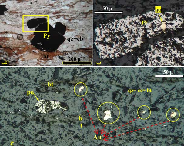
The main mineralization host rock of this region consists mainly of sedimentary and intrusive units with a degree of metamorphism of the green schist facies. Gold mineralization in a zone with a trend of around N25 degrees corresponding to the unit of granite Millionites and serysity with significant limonite affinities is occurred. The form of mineralogy is influenced by tectonic activities and boudinage. Gold grade has been reported from 100 ppb to 11500 ppb.

Main and mobile minerals:

Magnetite, Pyrotyte, Chalcopyrite, Pyrite, Free Gold, Limonite and Other Iron Hydroxides.


Exploratory actions have been taken and include the following:

Exploration activities in the area 102:

  • Geological mapping on a scale of 1: 5000 (10 sq. Km)
  • Lithogeochemical Exploration (1155) Litho and soil samples in 10 sq. Km
  • Lithogeochemical Exploration (2000) Litho and soil samples in 9.3 sq. Km
  • Preparation of topographic map on a scale of 1: 1000 (186 hectares)
  • Preparation of geological map on a scale of 1: 1000 (187 hectares)
  • Geophysical studies using magnetometry
  • Exploration trenching (41 trenches)
  • Sampling and trenching (1600 samples)
    • Geophysical studies by RS method (416 points)
    • Drilling and coring
    • Drill core logging and sampling (222 m)
    • 44-elemental ICP-AU analysis (3731)

    Exploration activities in the area 105:

    Geological mapping on a scale of 1: 5000 (29 hectares)

    Gold Analysis (94 samples)

    Preparation and study of thin sections (17)

    Geophysical study by IP-RS method (1320 points)

    Exploration activities in the area 103:

    • Prospecting exploration on a scale of 1: 20000 (50 sq. Km)
    • Digging 5 trenches totaling 262 cubic meters
    • Sampling and trenching (262 m)
    • Sample preparation and analysis of gold (200 samples)


    The quadrilateral position of the two exploration areas and the sampling location on the satellite image

    Exploration activities in the area 104:

    • Geological mapping on a scale of 1: 5000 (10.7 sq. Km)
    • Lithogeochemical exploration (1104 Lito and soil samples in the 9.7 sq km)
    • Preparation of topographic and geological map on a scale of 1: 1000 (110 hectares)
    • Exploration trenching (350 cubic meters)
    • Sample preparation and analysis of gold (1289)


This post is also available in: Persian